
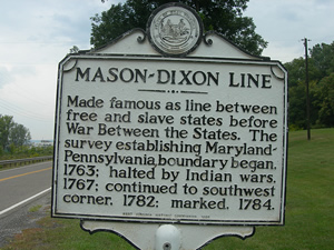
In the southwest corner of the state, near Mount Morris, there is a monument that reads: "MASON-DIXON LINE. Made famous as line between free and slave states before War Between the States. The survey establishing Maryland-Pennsylvania boundary began in 1763; halted by Indian wars 1767; continued to southwest corner in 1782; marked 1784." The text seems simple enough to understand. The marker stands to show where the North ends and the South starts. However, the story behind the boundary line is bitter, hostile and, at times, violent; and the story dates back to the mid-17th century.
Maryland State Archives
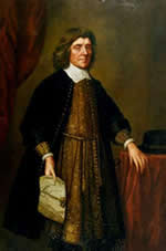
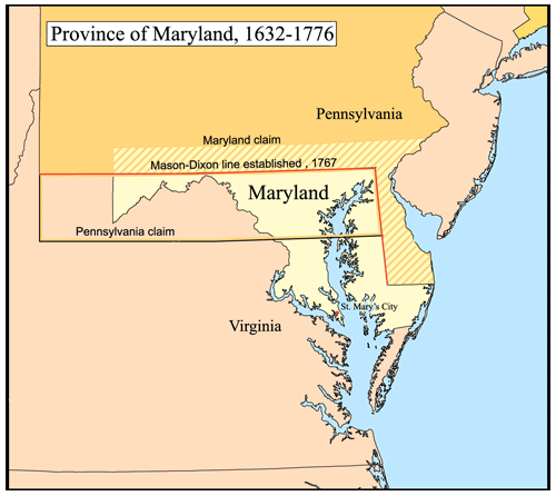
In 1632, King Charles I gave Cecilius Calvert the land that has since been named Maryland. The boundaries for Calvert's land were: in the north, the state began at the 40 degree north latitude line; in the south by the Potomac River and the latitude through Watkins Point on the Eastern Shore; in the east, the Atlantic Ocean; and, in the west, by a meridian through the source of the Potomac River. Three of these borders were created by natural landmarks and were easy to determine exactly when Calvert's land began. However, the northern border would become a problem.
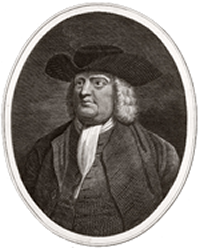
Nearly 50 years later in 1681, King Charles II gave William Penn the land that would be named Pennsylvania. Three of the boundaries for Penn's land were quite easy to measure: in the north, Penn's land ended at the 43 degree north latitude line; in the west, the land reached until a meridian five degrees west of the Delaware Bay; and in the east, the boundary was marked by the Delaware Bay. The southern boundary extended eastward along the fortieth parallel of north latitude until it intersected an arc extending in a 12-mile radius from the courthouse in New Castle, which is now in Delaware. However, the 40 degree latitude line and the circle do not intersect anywhere - in fact, at the closest point, they were 13 miles away. This created what has now been dubbed "The Wedge," although that land is now considered to be part of Delaware.
The dispute between the Penns and the Calverts began because they both claimed the land between the 39th and 40th parallels according to the charters granted to each colony. One of the reasons why this land dispute was so heated is that the historic city of Philadelphia falls within the disputed territory and both states wanted to claim the landmark as their own. However, land disputes were common in the 17th and 18th century because as American wilderness land was sold to English adventurers, the monarchs distributing the land did not have accurate maps, so new land proprietors only had a vague idea of what belonged to them.
For a while, Penn and Calvert each tried to convince the inhabitants of the disputed area that they were citizens of their state and should pay taxes appropriately. The residents did not necessarily care what state they lived in, but they did not want to pay taxes to both colonies. However, the battle between the Penn and the Calvert families continued for three generations without a truce. According to The History of Maryland by John Thomas Scharf, both William Penn II and Charles Calvert received a letter from the King of England in April 1681 requiring them "to make a true division and separation of the said provinces of Maryland and Pennsylvania, according to the bounds and degrees of our said Letters Patent and fixing certain Land Marks where they shall appear to border upon each other for the preventing and avoiding all doubts and controversies that may otherwise happen concerning the same."

Yet despite many meetings between the Penns and the Calverts in the coming years, no compromise was agreed upon and the tensions between the two families escalated even more. By the 1730s, the land dispute had grown increasingly violent. The hostilities launched Cresap's War, also known as the Conojocular War, which was series of skirmishes between the two colonies. The scuffle was named after Thomas Cresap - he had been raised in the colony of Maryland, but moved in 1730 to modern-day Wrightsville, in York County, Pennsylvania. Despite living in Pennsylvania, he remained incredibly local to Maryland. Since he was very vocal about his ties to Maryland, on several occasions, Pennsylvanian mobs tried to murder him and although he was never injured, some of his attackers were wounded. Due to his defense of Maryland, Pennsylvanians nicknamed him the "Maryland Monster," and since his antics had started other violent outbursts along the disputed border, the conflict was named after him.
Aside from the colorful personality of Cresap, his actions only added fuel to the fire that was already raging between the two colonies. In 1736, the Maryland militia got involved and the Pennsylvania militia followed in 1737. Although the militias stopped fighting in 1738, after King George II enacted a cease-fire, it would take more than another decade to fully end the dispute. In 1750, King George II stepped in again to create a truce which granted the Penns the borderline land, but no one knew for sure where the boundary line was. So Charles Mason and Jeremiah Dixon, two of the most respected English surveyors, were commissioned to travel across the Atlantic Ocean in hopes of finalizing the agreement between the two colonies. In England, Mason was an astronomer who had worked at the Royal Observatory and Dixon was a well-known surveyor. The two had worked together on a previous assignment and were chosen in part to their prior success as a team. A finalized contract was signed in 1763 by the grandsons of William Penn and Cecilius Calvert and shortly after then, Mason and Dixon arrived in Philadelphia.
Beginning in November 1763, Mason and Dixon set about determining the exact location of Philadelphia, so they could then base all measurements off that point of reference. Based on the land charters, the Pennsylvania-Maryland border was to be laid 15 miles due south of Philadelphia; this would become known as the "Post mark'd West." Nearly six months after they arrived in the colonies, Mason and Dixon had established that "Post mark'd West" lay in the latitude of 39 degrees 43 minutes 18.2 seconds north. From this spot, the famous Mason-Dixon Line would extend due west and east. The rest of their journey seemed simple: all they need to do was to walk the line east and west putting down markers as they went. However, before they laid the north-south line, they needed to finalize Pennsylvania's eastern border between what would become Delaware. This boundary became known as the "Tangent Line" and ran more than 80 miles from the Delaware Middle Point, which had been established 1751, to where it intersected 12-mile circle surrounding New Castle, Delaware.
Finally, in early April 1765, Mason and Dixon were ready to begin survey the Pennsylvania-Maryland border, what would become known as the Mason-Dixon Line. The first section of the West Line was easy enough to establish and by the end of May, they had traveled as far west as the Susquehanna River, which is border of modern-day York and Lancaster counties. Once Mason and Dixon arrived there, they completed Lord Baltimore's eastern boundary from the Tangent Point due north to the West Line. Continuing west from the Susquehanna River, through modern-day York County, they had reached the foot of the North Mountain, in modern-day Franklin County, by the end of October 1765. Beginning in the spring of 1766, Mason and Dixon made it from the North Mountain to Savage Mountain, part of modern-day Somerset County. Upon arriving at Savage Mountain, they had to stop again until the Native American chiefs of the Six Nations agreed to allow the surveyors through the region.
Since their journey had been filled with delays due to weather and Native American politics, Mason and Dixon used their free time to make other scientific gains. For example, in early 1766, they were the first people to measure the latitude in North America. Although ship captains had used latitudes at sea to determine where to dock the ship, no surveyor had measured the latitude on colonial soil. This also proved important in settling land disputes since frontiersmen had a more accurate way to mark their borders. The latitude measurement was primarily used by the Royal Society to add upon the work of the French Academie Royale des Sciences in defining the size and shape of the Earth.
Luckily for Mason and Dixon, by the end of 1766 they were on the move again and were able to extend the West Line eastward to the Delaware River. While they waited for the spring of 1767 to travel, they spent the winter making the first gravity observations in America. Mason and Dixon continue west again in July 1767 and made it to the Cheat River, which is part of the modern-day Fayette County. It had been nearly four years since they started their survey, but they had reached an impassable roadblock - hostile citizens. Mason and Dixon were unable to get any closer than about 36 miles away from the westernmost end of the line. The portion of the boundary line surveyed by Mason and Dixon was formally approved in early November 1768, which ended a battle between the Penns and the Calverts that had been ongoing for nearly 80 years. Ultimately, Mason and Dixon were not the ones to finish the project although the boundary still bears their names in memorial. In 1774, David Rittenhouse, the city surveyor for Philadelphia, set the remaining borders for between Pennsylvania and the surrounding colonies Maryland, New York and Virginia, as well as what would later become the Northwest Territory. His boundary lines between Pennsylvania and Maryland extended Mason and Dixon's work the 36 miles needed to reach its western destination.
As one studies the southern border of Pennsylvania, the boundary is anything but a horizontal line and it ignores any prominent land marks. In fact, it may even seem arbitrary for many observers, since most colonial borderlines were marked by natural dividers, such as rivers or a mountain range. However, considering the historical context of the line, the rises and fall of the line across the mountain ranges of the state match the challenges and obstacles in creating the boundary line more than 200 years ago.
Although Maryland is not always considered to be a southern state, the Mason-Dixon Line has become known as the boundary between the North and the South. When Mason and Dixon surveyed the land in the late 18th century, the border was never about slavery, yet it took on that association after 1780, when the Pennsylvania Assembly passed legislation that gradually ended slavery in the state. Focus on the thirty-six degrees and thirty-minute boundary line became even more intense after the Missouri Compromise (1820) was passed, which prohibited slavery in former French territories north of that line. Thus to the many slaves who used whatever means necessary to reach free land, the Mason-Dixon Line became important to their freedom. For the slaves located in Maryland, they only needed to get to the state line to secure their freedom, although many continued traveling north in an attempt to get as far away from their former masters as possible. Even today, the association of Pennsylvania's northern status lingers.
Even in popular culture references, it is clear to see the impact of Mason and Dixon's surveying. The 1953 Warner Brothers cartoon short "Southern Fried Rabbit," starring the typical Looney Tunes cast of characters, features the Mason-Dixon Line, as Bugs Bunny is trying to flee to North and head to Alabama to escape a carrot famine. Throughout the movie, the north is depicted as being barren and empty, while the south is lush and green. More recently, the award-winning 2006 Rocky Balboa film, the final film in the Rocky series, features a character named Mason "The Line" Dixon, which is significant since the movie is set in Philadelphia. On the music charts, many country songs mention the south being defined as below the Mason-Dixon Line. Johnny Cash sings about the border in his 1954 song, "Hey Porter." In the lyrics, a railroad porter is asked how much longer until the train crosses the Mason-Dixon Line, because the singer is longing to be back in the South, even though Cash wrote this while being stationed at a military base in Germany. In the 21st century, Mark Knopfler and James Taylor wrote a song "Sailing to Philadelphia" about the construction of the Mason-Dixon Line in. The songwriters cite Thomas Pynchon's book, Mason & Dixon, as the inspiration for their song. The 1997 novel brings the history of the surveyors and their work to life by suggesting what they may have experienced, based on their original journal entries.
Benchmarking Page
Benchmarking Page
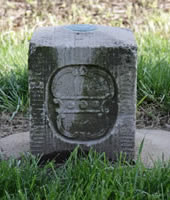
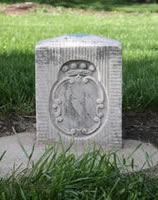
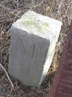
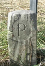
More than 225 years since Mason and Dixon finished, the boundary still stands and it has become the "most famous border in America," according to Edwin Danson's book Drawing the Line: How Mason and Dixon Surveyed the Most Famous Border in America. When the Mason-Dixon Line was originally finished, it was marked by more than 200 12" square monuments at 1-mile intervals. Each stone marked had a P on the north side, representing Pennsylvania land, and on the south side, an M was engraved, marking Maryland. Also, there was a larger stone placed every five miles, which was engraved with the Penn coat of arms on the Pennsylvania side and the Calvert coat of arms on the Maryland side. However, not all of those stones remain in the 21st century. According to Bijal P. Trivedi's National Geographic article entitled "Saving the Mason-Dixon Line," for over a decade two current surveyors Todd Babcock and Dilwyn Knott have been working to locate and document every stone that Mason and Dixon laid in the late-18th century to mark the Pennsylvania-Maryland line. They do have the advantage of using modern Global Positioning System (GPS) tools that Mason and Dixon did not have. In the article, Babcock said: "We're losing (the stones) at an increasing rate so it's very important that we obtain the precise location of each stone so we can go back and repair damaged stones and replace lost ones." The Mason-Dixon Line Preservation Partnership, of which Babcock is president, continues to work to preserve the history of the Mason-Dixon Line.
When Charles Mason and Jeremiah Dixon arrived in Philadelphia in November 1763, no one would have recognized them apart from the other passengers on the ship. However, after their five-year stay in the American colonies, their names are forever remembered with the border that separates Pennsylvania from Maryland and the other surrounding states. Most importantly for scientists and geographers around the country and world, when Mason and Dixon were surveying the line, they measured the first degree of latitude in North American and made the first scientific gravity measurements recorded across the Atlantic Ocean.
Sources:
- Bailey, Kenneth P. Thomas Cresap: Maryland Frontiersman. Boston: The Christopher House, 1944.
- Bedini, Silvio A. "American National Biography Online: Rittenhouse, David." American National Biography Online. Feb. 2000. American Council of Learned Societies. 10 Sept. 2008 <http://www.anb.org/articles/13/13-01396.html>.
- Danson, Edwin. "American National Biography Online: Mason, Charles and Jeremiah Dixon." American National Biography Online. Jan. 2002. American Council of Learned Societies. 10 Sept. 2008 <http://www.anb.org/articles/13/13-02640.html>.
- Danson, Edwin. Drawing the Line: How Mason and Dixon Surveyed the Most Famous Border in America. New York: Wiley, 2000.
- Ecenbarger, William. Walkin' the Line: A Journey from Past to Present Along the Mason-Dixon. Boston: M. Evans & Company, Incorporated, 2001.
- Lancaster County Historical Society. Historical Papers and Addresses of the Lancaster County Historical Society. 1909.
- Mannix, Mary. "Biography of Thomas Cresap." Maryland Online Encyclopedia. 2005. 17 Sept. 2008 <http://www.mdoe.org/cresapthomas.html>.
- Mason, Charles, and Jeremiah Dixon. The Journal of Charles Mason and Jeremiah Dixon. Philadelphia, PA: American Philosophical Society, 1969.
- Rosenberg, Matt. "The Mason-Dixon Line." About.com. 17 Aug. 2007. New York Times Company. 10 Sept. 2008 <http://geography.about.com/od/politicalgeography/a/masondixon.htm>.
- Scharf, John T. History of Maryland: From the Earliest Period to the Present Day. Hatboro, PA: Tradition Press, 1967.
- "The Mason & Dixon Line Preservation Partnership." Mason & Dixon Line Preservation Partnership. Oct. 2007. Mason & Dixon Line Preservation Partnership. 3 Sept. 2008 <http://www.mdlpp.org/>.
- Trivedi, Bijal P. "Saving the Mason-Dixon Line." National Geographic Today. 10 Apr. 2002. 10 Sept. 2008 <http://news.nationalgeographic.com/news/2002/04/0410_020410_tvmasondixon....
- Veech, James. Mason and Dixon's Line: A History, Including an Outline of the Boundary Controversy Between Pennsylvania and Virginia. Pittsburgh: W.S. Haven, 1857.